
 Yahoo News
 MH17 Plane Crash Site Seen from Space (Photo)
Satellites have captured images of the scattered debris and charred wreckage from last week's crash of Malaysian Airlines Flight MH17 in eastern Ukraine that killed all 298 people on board.
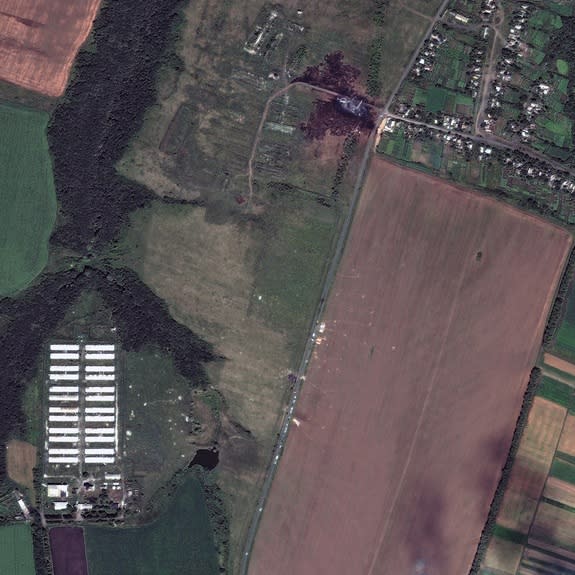
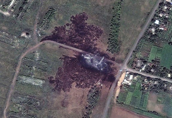
DigitalGlobe, a Colorado-based company, programmed three of the five Earth-watching satellites in its commercial fleet to look at the crash site shortly after the plane was shot down by a missile on Thursday, July 17. Cloud cover obscured images of the ground that day. DigitalGlobe was finally able to capture clear, high-resolution images of the crash site yesterday (July 20) and today (July 21).
In the top half of the image, the main debris field can be seen inside a blackened splotch of earth near the village of Hrabove in the Donetsk region in eastern Ukraine, which has been embroiled in conflict as Ukrainian forces and Russian-backed separatists fight for control of the region. Other crash fragments and white pieces of the plane, which broke apart in the air, are visible in the lower half of the image, littering farmland along the road that cuts from north to south. [Earth from Above: 101 Images from Orbit]
The crash site has become a focal point for outrage over the attack on MH17, which was flying from Amsterdam to Kuala Lumpur, Malaysia. Pro-Russian rebels had obstructed a team of international investigators from getting close to the wreckage for days and are suspected to have tampered with evidence and hastily handled bodies at the site, according to news reports.
"We have to make sure that the truth is out and that accountability exists," U.S. President Barack Obama said in an address from the White House today, urging Russian authorities and President Vladimir Putin to compel the separatists to cooperate with the independent investigation.
Hours after Obama spoke, the rebels agreed to hand over the plane's black boxes to Malaysian authorities, turn over human remains to Dutch officials and allow investigators onto the crash site, The New York Times reported.
DigitalGlobe frequently aims its satellites at sites of natural and man-made disasters. The company released images of a devastating landslide in Washington state earlier this year that killed more than 40 people. Archaeologists have used DigitalGlobe images to document looting at ancient ruins in war-torn Syria. The company's sixth satellite, dubbed WorldView-3, is expected to launch this year.
Follow Megan Gannon on Twitter and Google+. Follow us @livescience, Facebook & Google+. Original article on Live Science.
Copyright 2014 LiveScience, a TechMediaNetwork company. All rights reserved. This material may not be published, broadcast, rewritten or redistributed.
